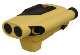
A light weight laser, 300 metre range, built in inclinometer, optional horizontal
angle encoder, or compass, with a data logger. An ideal companion for dXm and rockmate BOS
This is a non contact survey instrument. (no need for a chain man!)
No need for a target, just point and shoot, take shots on inaccessible points.
The perfect instrument for surveying stockpiles.
Take 1000 shots in the same length of time it will take you to collect 100 with a conventional surveying instrument.
Use dXmCubed to process and calculate the volume.
dXmCubed has been specially configured to simplify stockpile measurements with the LaserAce and ALS.
Multiple setups are easy with dXmCubed.
Distance accuracy +/-10 cm,
Inclinometer accuracy 0.3 deg at 0 degree
Horizontal angle encoder accuracy 0.2 deg, resolution 0.1 deg
Electronic compass accuracy 1 Deg
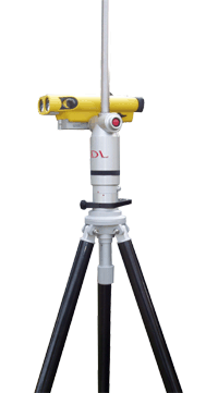
Dome head light weight aluminium tripod.
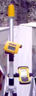
The LaserAce® encoder is used to provide an accurate horizontal angle where the use of a fluxgate compass is not suitable.
The MDL LaserAce® 300 instrument is attached to the encoder via the cableless hot-shoe and the results shown on the
LaserAce® LCD screen.
A "zero" button is included for easily reference of a back sight.
The encoder can be mounted on a special monopod or lightweight tripod. The battery pole is threaded to take a GPS antenna or 360 degree prism.